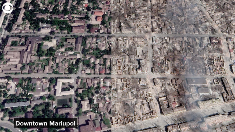
The scale of the devastation unleashed on Ukraine since Russia launched its full-scale invasion has been vividly captured in satellite images from the Google Earth public website.
A recent update to Google Earth’s public satellite imagery includes snapshots of Ukrainian towns and cities since Russian President Vladimir Putin’s forces first attempted to seize the country. The trail of destruction is so vast that it can be seen from space.
Entire neighborhoods have been reduced to rubble, with debris strewn across streets and little left of once bustling towns – in stark contrast to images captured of the same locations before the Feb. 24, 2022, full-scale invasion began.
Among the starkest contrasts are before and after images of the southern port city of Mariupol, where a devastating airstrike killed hundreds of civilians sheltering in a public theater. The images show the once grand theater completely destroyed, with its roof collapsed and its walls crumbling.
Closer to the capital city of Kyiv, the strategic site of Hostomel airport was the scene of intense fighting in the early days of the war. Russian troops tried but failed to take control of the airport to establish an air bridge close to the capital.
But while Ukrainian forces eventually secured control of the key piece of infrastructure, the satellite imagery shows its runway and surrounding fields peppered with craters from explosions.
Another set of sobering images show the town of Bucha, one of the most notorious scenes of alleged Russian war crimes, littered with the remnants of Russian tanks and armored vehicles.
As Ukraine forces started retaking occupied areas last year, dozens of alleged atrocities against the civilian population were revealed in Bucha. CBS News was there soon after the Kyiv suburb was reclaimed, and our team saw civilian bodies still littering the streets, some with bullet wounds and their hands bound behind their backs.
Source : CBSNews


